Fort Smith, Arkansas
| Fort Smith, Arkansas | |
|---|---|
| — City — | |
 |
|
| Nickname(s): Hell on the Border | |
| Motto: "Life's worth living in Fort Smith, Arkansas" [1] | |
 |
|
| Coordinates: | |
| Country | United States |
| State | Arkansas |
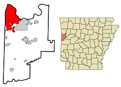
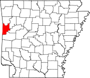
| County | Sebastian |
| Founded | 1817 |
| Incorporated | 1842 |
| Government | |
| - Mayor | Ray Baker |
| Area | |
| - City | 52.9 sq mi (137.1 km2) |
| - Land | 50.3 sq mi (130.4 km2) |
| - Water | 2.6 sq mi (6.7 km2) |
| Elevation | 463 ft (141.1 m) |
| Population (2000) | |
| - City | 80,268 |
| - Density | 1,639.8/sq mi (632.5/km2) |
| - Metro | 273,170 |
| Time zone | CST (UTC-6) |
| - Summer (DST) | CDT (UTC-5) |
| Area code(s) | 479 |
| FIPS code | 05-24550 |
| GNIS feature ID | 0076952 |
| Website | http://www.fortsmithar.gov |
Fort Smith is the second-largest city in the U.S. state of Arkansas and one of the two county seats of Sebastian County.[2] With an estimated population of 85,544 in 2009, it is the principal city of the Fort Smith, Arkansas-Oklahoma Metropolitan Statistical Area, a region of 293,063 residents which encompasses the Arkansas counties of Crawford, Franklin, and Sebastian, and the Oklahoma counties Le Flore and Sequoyah.
Fort Smith has a sister city relationship with Cisterna, Italy, site of the World War II Battle of Cisterna fought by the United States Army Rangers commanded by Fort Smith native William O. Darby.
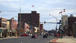
Fort Smith lies on the Arkansas-Oklahoma state border, situated at the junction of the Arkansas and Poteau Rivers, also known as Belle Point. The city began as a western frontier military post in 1817 and would later become well-known for its role in the settling of the "Wild West" and its law enforcement heritage.
In 2007, Fort Smith was selected by the US Department of the Interior to be the location of the new US Marshal Service National Museum.
Contents |
History
Fort Smith was founded in 1817 as a military post to keep the peace between the Osage Indians and emigrating Cherokee in the neighboring Indian Territory. The Army abandoned the first Fort Smith in 1824 and moved 80 miles further west to Fort Gibson to be closer to the center of Osage territory. Army sutler and land speculator John Rogers (who some genealogists claimed to be an ancestor to 20th-century Oklahoma comedian Will Rogers) bought up former government-owned lands and promoted growth of the new civilian town of Fort Smith, eventually influencing the federal government to re-establish a strong military presence at Fort Smith during the era of Indian Removal and the Mexican War.
Fort Smith's name comes from General Thomas Adams Smith (1781–1844), who commanded the United States Army Rifle Regiment in 1817, headquartered near St. Louis. General Smith had ordered Army topographical engineer Stephen H. Long (1784–1864) to find a suitable site on the Arkansas River for a fort. General Smith never visited the town or forts that bore his name.
In 1838 the Army moved back into the old military post near Belle Point, and expanded the base as part of the federal policy of removing Cherokees and Choctaws from their ancestral homelands in the Southeast and resettling the survivors in the nearby Indian Territory. Many displaced Native Americans settled down in Fort Smith and Van Buren, while Sebastian county was formed in 1851, split from Crawford county in the north of the Arkansas River. In 1871 the U.S. Army moved out of the second Fort Smith. The fort had been occupied by the Confederate Army during the early years of the U.S. Civil War. Union troops under General Steele took control of Fort Smith on 1 September 1863 and maintained command in the area until the war ended in 1865. The town became a haven for runaway slaves, orphans, Southern Unionists, and other victims of the ferocious guerrilla warfare then raging in the Border States. Federal troops abandoned the post of Fort Smith for the last time in 1871. The town continued to thrive despite the absence of federal troops.
Two of Fort Smith's most notable historic figures were Judge Isaac Parker and William Henry Harrison Clayton. In 1874, William Henry Harrison Clayton was appointed United States Attorney for the Western District of Arkansas by President Ulysses S. Grant. Fort Smith was a bustling community full of brothels, saloons and outlaws across the river from Indian Territory. William Clayton realized that a strong judge would be necessary to bring law and order to the region. He knew of a strong judge in Isaac Parker. There was a problem, Judge Parker had been appointed Chief Justice of Utah Territory and confirmed by the US Senate. With the help of President Grant and US Senator Powell Clayton, former governor of Arkansas, William Clayton was able to undo that appointment and redirect Judge Parker to Fort Smith.
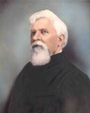
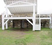
Judge Isaac Parker served as US District Judge from 1875-1896. He was nicknamed the "Hanging Judge" because in his first term after assuming his post he tried eighteen people for murder, convicted fifteen of them, sentenced eight of those to die, and hanged six of them on one day. Over the course of his career in Fort Smith, Parker sentenced 160 people to hang, of those 79 actually were executed on the gallows. Judge Parker represented the only real law the rough and tumble frontier border town had at the time. His courthouse is now a National Historic Site where "More men were put to death by the U.S. Government... than in any other place in American history."[3]
William Clayton was appointed US Attorney by four different presidents and later served as Chief Justice of Indian Territory. He was instrumental in achieving statehood for Oklahoma and together with Territorial Governor Frank Frantz, carried the Oklahoma Constitution to President Teddy Roosevelt after that state was admitted in 1907. Governor Frantz and Judge Clayton both lost their territorial positions when Oklahoma was admitted to the Union. Fort Smith foresaw an economic boom in World War I and the 1920s by the US Armed Forces in the Fort Chaffee Military Reservation established east of the city.
Geography and climate
Fort Smith is located at (35.368691, -94.398737).[4]
According to the United States Census Bureau, the city has a total area of 52.9 square miles (137 km2), of which, 50.3 square miles (130 km2) of it is land and 2.6 square miles (6.7 km2) of it (4.89%) is water.
Fort Smith has generally mild winters and hot, humid summers. Winter daytime highs average near 50 degrees while summer highs often top 90 degrees. Fort Smith is situated near an area known as Tornado Alley in the central United States. The city has been struck by three major tornadoes which occurred in the years of 1898, 1927 and 1996.
| Climate data for Fort Smith, Arkansas | |||||||||||||
|---|---|---|---|---|---|---|---|---|---|---|---|---|---|
| Month | Jan | Feb | Mar | Apr | May | Jun | Jul | Aug | Sep | Oct | Nov | Dec | Year |
| Source: USTravelWeather.com [5] | |||||||||||||
Economic base
Fort Smith has long been a regional manufacturing center, with major plants located in the city operated by Whirlpool Corporation, Rheem, Trane, Georgia-Pacific, Gerber, Planters Peanuts and others. In recent years, following national trends, the city has seen a decline in manufacturing jobs as production lines are shifted overseas.
Fort Smith is home to several corporations including Baldor Electric Company, Arkansas Best Corporation, Golden Living (Formerly Beverly Enterprises, Inc.) (one of the largest nursing home health care providers in the nation) and poultry company OK Foods.
Transportation
Fort Smith is a major transportation hub for the surrounding region. It sits at the crossroads of two major interstate highways, is surrounded on three sides by the Arkansas River, is served by 1 major and 2 regional/switching railroad companies, and is the home of a regional airport.
Road
The city sits just southwest of the intersection of Interstate 40 and future Interstate 49 when it extends southward to meet Interstate 30 in Texarkana, Texas. US 71 and US 64 also run through the community.
Air
Fort Smith is served by the Fort Smith Regional Airport (FSM), which is used for military aviation for Fort Chaffee and home of the 188th Fighter Wing of the Arkansas Air National Guard, but is also served by three commercial airlines with flights to Dallas/Fort Worth and Memphis.
Bus
Jefferson Lines bus service also links Fort Smith to other communities such as Little Rock, Kansas City, and Oklahoma City, as well as intermediate points, with numerous connections to other cities and towns.
River
The city is located on the Arkansas River, part of the McClellan-Kerr Navigation System and is served by the Port of Fort Smith.
Rail
Fort Smith is served by the Kansas City Southern Railway from a branch connection on the mainline at Poteau, Ok and affords connections to other railroads at Kansas City, MO and at New Orleans, LA. In addition, the regional railroad company, the Arkansas and Missouri Railway directly serves Fort Smith and provides connections through the St. Louis, MO and Memphis gateways to the east. The Fort Smith Railroad provides local switching service to a variety of businesses as well as providing haulage for the Union Pacific Railway with which it connects at Van Buren, AR.
At this time, there is no direct passenger service from Amtrak. The closest point for such service is Little Rock, AR.
Public transport
Inside the city, a public bus service named Fort Smith Transit operates several routes.
A trolley bus operates in the downtown area, providing transportation between the Belle Grove Historic District and the Fort Smith National Historic Site.
Demographics
As of the census[6] of 2000, there were 80,268 people, 32,398 households, and 20,637 families residing in the city. The population density was 1,594.2 people per square mile (615.5/km²). There were 35,341 housing units at an average density of 701.9/sq mi (271.0/km²). The racial makeup of the city was 75.00% White, 8.65% Black or African American, 2.00% Native American, 4.59% Asian, 0.05% Pacific Islander, 5.03% from other races, and 2.99% from two or more races. 8.78% of the population were Hispanic or Latino of any race, but the United States Hispanic Chamber of Commerce placed the figure at above 10 percent or one-eighth by the late 2000s.
In language, Fort Smith has over 10 Asian languages with over 2 percent and the rise of Hispanics from immigration in the late 20th century increased the total of residents who speak Spanish. 7.10% reported speaking Spanish at home, while 3.38% speak Vietnamese and Lao, and 2.50% speak Tagalog.[7]
There are 32,398 households, of which 30.8% have children under the age of 18 living with them, 47.1% were married couples living together, 12.3% had a female householder with no husband present, and 36.3% were non-families. 30.7% of all households were made up of individuals and 10.9% had someone living alone who was 65 years of age or older. The average household size was 2.42 and the average family size was 3.03.
In the city the population was spread out with 25.4% under the age of 18, 9.8% from 18 to 24, 29.3% from 25 to 44, 21.8% from 45 to 64, and 13.7% who were 65 years of age or older. The median age was 35 years. For every 100 females there were 94.1 males. For every 100 females age 18 and over, there were 91.0 males.
The median income for a household in the city was $32,157, and the median income for a family was $41,012. Males had a median income of $29,799 versus $22,276 for females. The per capita income for the city was $18,994. About 12.1% of families and 15.8% of the population were below the poverty line, including 22.2% of those under age 18 and 9.6% of those age 65 or over.
| Year | Population | Year | Population |
|---|---|---|---|
| 1900 | 11,600 | 1950 | 47,900 |
| 1906/07 | 23,500 | 1960 | 53,000 |
| 1910 | 24,000 | 1970 | 62,800 |
| 1916/17 | 28,600 | 1980 | 71,800 |
| 1920 | 28,900 | 1990 | 72,800 |
| 1930 | 31,400 | 2000 | 80,268 |
| 1940 | 36,600 |
Neighborhoods
Fort Smith features some of the best homes in the southwest. With gentle rolling hills, the Ozark and Boston mountains, pristine lakes and wooded areas wrapping in and around the Arkansas and Poteau Rivers, the rustic beauty of the region is hard to find anywhere else.
- Downtown
The riverfront area and the Belle Grove Historic District are nestled in the downtown area where the old west meets the new Fort Smith. The Fifth, Sixth, Seventh and Eighth Streets of the Belle Grove District encompass a 22-block area reflecting architecture from the past 130 years. Listed on the National Register of Historic Places, the restored homes and buildings are preserved from the neighborhoods that grew around the needs of the soldiers and officers in the trading post and fort. The charming neighborhood is a walk down memory lane but only steps away from fine dining, theatre and retail centers.
- Hillcrest and Park Hill
Located just outside of the downtown area, both neighborhoods are rooted in the history and traditions of Fort Smith. Cottages and bungalows line the streets under tall, mature trees. The area is quaint, quiet and reminiscent of a relaxing summer afternoon.
- Free Ferry Landing
Further down the river is Free Ferry Road, so named because it ended at the river and was the site of a free ferry to Oklahoma. Today this street is full of Fort Smith pride and is dotted with old, gracious homes. This nostalgic area provides amazing views of the river with quiet living yet is still minutes away from the hustle and bustle of the city. It’s a great place to raise a family.
- Eastgate
These newer developments are located in the east central section of the city and provide topnotch design for those seeking an affordable but upscale community. Surrounded by beautiful hills, these houses offer breathtaking views of the Arkansas River, the mountains of Oklahoma and the Carol Ann Cross Park.
- Skyline Estates
This residential area is the highest elevation in Fort Smith and was originally established in the 1970s. Many of the homes are surrounded by acres of lush, green pastures. The homes are slightly off the beaten path, and deer and other wildlife are abundant.
- Massard Creek and Village Harbor
Homeowners here are surrounded by the Arkansas River and are treated with the Village Harbor Marina for boat storage and docking in a sheltered cove. Convenient to everyday life amenities, this residential area is still tranquil and serene.
- Midland
The north end of town boasts the University of Arkansas at Fort Smith and Kay Rodgers Park, home to the Old Fort Days Rodeo and the Arkansas-Oklahoma State Fair. The residential areas are well-established with expansive lawns and beautiful landscaping. The homes are quiet and private but still convenient and full of youth.
- Fianna Hills
This neighborhood began in the 1970s as five small streets around the Fianna Hills Country Club and quickly grew into a sprawling community with an urban feel. The tree-lined streets offer views of Oklahoma and luscious woodlands.
- Belle Chasse
The west side of Fort Smith boasts stately homes in a secluded area that is still accessible to the metro areas. This neighborhood is family-oriented and full of outside activities.
- Riley Farms
One of the newest addition to Fort Smith, Riley Farms is full of homes that are full of character and design. The 500-acre development is located south of Fort Smith on a preservation park with a nature trail through the woodlands. Although perfect for lazy Sunday afternoons, the area is still minutes away from the heart of the city.
- Chaffee Crossing
Fort Smith's newest neighborhood, Chaffee Crossing was previously part for Fort Chaffee. Chaffee Crossing is the center point of the nation’s crossroads. It is a unique place on the map where natural resources, transportation, affordable living and national history converge to create an exciting mixed-use environment for work, play, exploration and learning. Chaffee Crossing is poised to become Arkansas’ premier community where Smart Growth planning is key.
Education
The city has one major university that is part of the University of Arkansas System. The University of Arkansas at Fort Smith was founded in 1928 as an extension of the Fort Smith Public School system, with the superintendent acting as the college president and the high school principal as dean. Known originally as Fort Smith Junior College, the institution operated within the Fort Smith public school system until 1950, when the school was incorporated as a private, nonprofit institution with its own governing board. In September 1952, the College moved from borrowed facilities in the high school to its current site, initially occupying 15 acres.
During the private college era, enrollment increased, as did course offerings, the number of faculty, and facilities. A vocational-technical division was added in 1960. During this period, the college began developing the programs and character of a comprehensive community college — a new concept in Arkansas and across the nation.
In the fall of 1965, the Sebastian County electorate approved the creation of the Sebastian County Community Junior College District, along with a tax levy on the real and personal property of the county. The governor appointed a Board of Trustees, and the school again became a public institution.
In 1966, the institution’s name was changed from Fort Smith Junior College to Westark Junior College, and in 1972, to Westark Community College, indicating the larger area to be served and reflecting the more comprehensive mission.
Throughout the 1980s and early 1990s, the college developed and made changes within the context of its mission as a two-year institution. A significant development in 1989 was the establishment of a University Center. Five state universities partnered with the institution to offer six bachelor’s and seven master’s degree programs on campus. Between 1989 and 2002, 1,788 students graduated with bachelor’s degrees through the University Center.

In 1997, the Arkansas Legislature passed an act granting Westark the authority to offer in its own right up to nine applied bachelor’s degrees, developed in response to identified needs of the industries in the area served.
The name of the college was changed yet again in February 1998 to Westark College, more accurately portraying the role and scope of the institution.
On December 15, 2000, the Board of Trustees of Westark College entered into an agreement with the Board of Trustees of the University of Arkansas to merge with the University of Arkansas System as a four-year institution. In 2001, the Sebastian County electorate voted to support the merger. A formal request to change affiliation status to that of a bachelor’s degree-granting institution under the name of the University of Arkansas – Fort Smith was submitted to the Higher Learning Commission in August 2001 and approved by the Institutional Actions Council on November 19, 2001.
The merger, which became official on January 1, 2002, endorsed the concept of UA Fort Smith as a unique university, one that offers applied and traditional baccalaureate degree programs, one- and two-year associate and technical programs, and noncredit business and industry training programs. While the University of Arkansas at Fort Smith is the city's only state supported institution of higher learning Webster University and John Brown University each have a satellite campus located in the city.
The public schools in Fort Smith and Barling are operated by the Fort Smith Special School District. Currently, the district includes 26 schools. As of the 2007-2008 school year, the district has enrollment of more than 13,900. It has 2 high schools, 4 junior high schools, 19 elementary schools, and 1 alternative learning center. Fort Smith public schools provide education from kindergarten through the 12th grade, as do some private Protestant schools. Catholic parochial schools offer education through the ninth grade.
Jr. high schools in Fort Smith include:
Public:
- LA Chaffin Junior High School
- Ramsey Junior High School
- Dora Kimmons Junior High School
- William O. Darby Junior High School
Private:
High schools in Fort Smith include:
Public:
- Northside High School
- Southside High School
Recreation and Sports
In addition to sports teams sponsored by the schools and UA Fort Smith, Fort Smith has several independent recreational sports programs administered by local organizations. These include:
- River Valley Roller Girls, local roller derby league, est. 2006.
- The River Valley Gaelic Athletic Association, formed in 2009, is recruiting athletes who wish to learn to play Gaelic Football and hopes to expand to Hurling if enough interest is generated.
- Fort Smith Express Soccer, offers clinic, recreational and travel leagues.
- The Fort Smith Boys and Girls Club, offers recreational leagues in Football, Soccer, Baseball, Basketball and Cheerleading, among others.
- Fort Smith Church League Baseball, administers a faith based baseball league made up of teams representing individual churches and houses of worship from the surrounding area.
- Fort Smith Juniors Volleyball, offers girls volleyball.
- Ben Geren Park Softball, has co-ed softball teams for youth and adults.
- The First Tee of Fort Smith
- Western Arkansas Tennis Association
- Fort Smith Tide Riders, Fort Smith's hometown Swim Team
Media
Local Radio Stations
AM radio Stations in the Fort Smith area include:
| Call letters | Frequency | Format |
|---|---|---|
| KFSA | 950 | Christian |
| KFPW | 1230 | Nostalgia |
| KYHN | 1320 | News Talk |
| KWHN | 1650 | News Talk |
FM Radio Stations in the Fort Smith area include:
| Call letters | Frequency | Format |
|---|---|---|
| KAOW | 88.9 | Religious |
| KISR | 93.7 | Top 40 |
| KERX | 95.3 | Classic Rock |
| KKBD | 95.9 | Classic Rock |
| KZBB | 97.9 | Variety |
| KMAG | 99.1 | Country |
| KTCS | 99.9 | Country |
| KLSZ | 100.7 | Rock |
| KBBQ | 102.7 | Urban/Hip Hop |
| KHGG | 103.1 | Sports |
| KQBK | 104.7 | Oldies |
| KEZA | 107.9 | Adult Contemporary |
Local TV Stations
Television stations in the Fort Smith area include:
| Call letters | Number | Network |
|---|---|---|
| KFSM | 5 | CBS |
| KFDF-CA | 10 | This TV |
| KFTA | 24 | Fox |
| KHBS | 40 | ABC |
| KPBI-CA | 46 | My Network TV |
Local Newspapers
- Southwest Times Record
Culture
Fort Smith has a thriving arts community, with a number of venues to support performances. The Fort Smith Convention Center, constructed in 2001, brings national tours of many popular bands to downtown, and the Arkansas Best Corporation Performing Arts Center provides an excellent venue for orchestras and plays.
Museums
- Fort Smith Regional Art Museum is housed in the Vaughn-Schapp House. Today it houses galleries of fine paintings, sculptures, and permanent and changing exhibits. In 2011 the RAM will move into a new state of the art and larger building thanks Arvest Bank. The new museum will be climate-controlled and equipped to facilitate traveling exhibits and handsomely display the museum's permanent collection.
- Fort Smith Museum of History, almost adjacent to the National Historic Site the museum contains numerous exhibits, displays and artifacts that tell the story of Fort Smith's colorful history - from the first fort in 1817, through the westward expansion, and on to the Civil War, the Gay Nineties, Fort Chaffee, and the emergence of a modern city.
- Fort Smith Trolley Museum is a railroad museum which displays a number of antique trolleys and related items.
- Fort Smith Air Museum is dedicated to preserving the history of the development of aviation in Western Arkansas and Eastern Oklahoma.
- National U.S. Marshals Museum: The U.S. Marshals Museum is being designed to provide the richest of visitor experiences. Every facet will support learners of all ages in ways that are engaging, hands-on, fun and inspiring. It will bring together the most current of ideas from museum designers, architects and educators to assure that the total experience is one that will evoke conversation and memories that last for years. While construction of the U.S. Marshals Museum has not begun, educational programming is well underway.
Music
Fort Smith has an active music scene, with frequent live performances in the downtown area by local and national Jazz, Blues, Country, and Rock bands. Local bands regularly frequent the riverfront area highlighting the river valley's finest, including blues, bluegrass, country, rock, and heavy metal. Regular local artists include: Oreo Blue, Mr. Cabbage Head and the Screaming Radishes, Truck Stop Poets, Blame Kelly, Barefoot Brigade, Copesetic, The Bannister Brothers, S.I.C.,Judge Parker, Three Foot Pete, The Hubbard Fry Band, Brandon White and acts from all around the region. There is even a thriving local Celtic Music band, Cold Water Dog.
- Fort Smith Symphony, the oldest orchestra in the state. The symphony is a per-service professional orchestra composed of musicians from Fort Smith, Fayetteville, Springfield, Tulsa, Oklahoma City, Norman, Dallas, Little Rock, New York, Florida and other communities. The Fort Smith Symphony, conducted by John Jeter, regularly performs at the Arkansas Best Performing Arts Center.
- Fort Smith Chorale, founded in 1981 by Bill Cromer for the purpose of providing singers with the opportunity to learn and present Chorale music otherwise not available to them locally.
- Fort Smith Community Brass Band, A British Style Brass Band founded by Michael Cash, which is based in and sponsored by the Salvation Army. The band is composed of students from both high schools and the university.
Dance and theatre
- Western Arkansas Ballet, a regional dance company which regularly presents programs at area schools and the Performing Arts Center. Their major annual event is the presentation of Tchaikovsky's Nutcracker Ballet.
- The McCafferty School of Irish Dance, offers instruction in the art of Traditional Irish Dance. Dancers from the school have competed at local, regional, national and world championship levels of competition. Dancers from the McCafferty School have also performed professionally in international shows such as Riverdance and Lord of the Dance. Dancers perform at many local celebrations including Oktoberfest, The Saint Patrick's Day Parade, church carnivals and many others. The Fort Smith branch of the school is supported by the Fort Smith Irish Dance Council, a 501(c)3 Non-Profit Organization founded to provide support and facilities for the dancers. The Council maintains a studio at Chaffee Crossing for the use of the school. The Council hosts the The River Valley Feis, a regional dance competition held at the Fort Smith Convention Center each November. The Feis serves as the Council's primary means of fund raising.
Attractions
As the largest city in western Arkansas, Fort Smith offers many activities and attractions. Fort Smith's theatres and event venues regularly host major concerts and touring theatre companies.
Event venues
- Riverfront Amphitheater, Located next to the Arkansas River, the Riverfront Amphitheater represents one-third of the River Park Complex.
- Fort Smith Convention Center, is one of the largest convention centers in the region. It has more than 40,000 square feet (3,700 m2) of exhibition space. Many trade shows, conventions, and other events are held here each year. The performing arts theater is home to the Fort Smith Symphony and has seating for 1,331 people.
- Kay Rodgers Park, home to the Expo Center, with 24,000 square feet (2,200 m2) of meeting and exhibition space, and the Harper Arena. The Harper Arena is a covered open-air stadium that can seat 7,000 to 14,000 attendees for a variety of events.
- Phoenix Expo Center This 80,000-square-foot meeting and expo center is largest in the Great Fort Smith Region. What was once one of Arkansas' first malls is now a multi-purpose facility can accommodate virtually any event, including conventions, concerts, trade shows, conferences, sporting events and most any special event.
- Fort Smith Event Center The two room complex includes 17,000 square feet of function space which can accommodate from 100 to 999 people, depending on seating needs.
- River Valley Celebration Center Fort Smith's newest event center, providing building rentals for private functions and public events, located at 1022 Dodson Ave in what was once the UCT Hall. They offer 6000 sq ft and can accommodate 290 and employ a photographer and DJ.
- Second Street Live This Performing and Visual Arts Center has an intimate 250 seat theater and 1500 square foot Art Gallery.
Shopping
Fort Smith is the main shopping destination of Western Arkansas and Eastern Oklahoma. For more specialized shopping, Fort Smith has Central Mall, which is the state's largest indoor shopping center in terms of square footage. Many national chain big-box retailers including Dillard's, J.C. Penney, Target, Kohl's, Sears, Kmart, Wal-Mart, Sam's Club, Best Buy, Lowes, Home Depot, Old Navy, and Finish Line have stores in Fort Smith.
Landmarks
- Fort Smith National Historic Site, the most prominent landmark, which includes the remains of the original 1817 fort on the Arkansas River. Inside is the restored courtroom of the famed "Hangin' Judge" Isaac C. Parker, and the dingy frontier jail aptly named "Hell on the Border." Eventually, this would become the unofficial nickname for all of Fort Smith.
- Belle Grove Historic District, a 22-block area in downtown Fort Smith comprised nearly 25 restored homes that span 130 years of varying architectural styles.
- Miss Laura’s Social Club, a former brothel and the only remaining building from the Row, is home to the city’s Convention and Visitors Bureau and the only former house of prostitution on the National Register of Historic Places.
- Fort Chaffee, primarily used as a training facility by regional National Guard and Reserve Corps units as well as active military units from other installations. In 1958, the entertainer Elvis Presley stopped off at Fort Chaffee en route to his basic training in Texas. It was here that the public information officer John J. Mawn told a news conference that Presley would receive the standard "G.I. haircut" and would resemble a "peeled onion".
- Ed Walker's Restaurant, home of what is believed to be the biggest hamburger sold in the state of Arkansas.
Annual attractions
- Old Fort Days Rodeo, Fort Smith's annual Old Fort Days Rodeo and Barrel-Racing Futurity offers nearly ten days of Wild West activities. It has been held every May since the mid-1930s and is now rated as one of the top all around rodeos in the country.
- Hanging Judge Border Feud High School Rodeo, the rodeo is held every March or April schedule permitting. This event is held at Kay Rodgers Park, and includes all of your usual rodeo events as well as the spring livestock show. The events are open to any high school students.
- Fort Smith Riverfront Blues Fest, since it began in 1991, the Riverfront Blues Festival has become one of the biggest, hottest and jazziest annual June events in western Arkansas and eastern Oklahoma, attracting jazz aficionados from a wide area of the blues-rich south, and "name" blues artists and performers from all over. The two-day event makes for a delightful music-filled weekend in Fort Smith, hearing blues, blues, blues on the banks of the Arkansas River.
- Arkansas-Oklahoma State Fair, One of the largest bi-state fairs in the nation, Fort Smith's Arkansas-Oklahoma State Fair attracts thousands of fair-goers during its ten-day run in late September. They come to see exhibitor competition in everything from arts and crafts to livestock, and enjoy carnival rides, the midway excitement, nightly big-name grandstand entertainment, and plenty of good food.
- Fort Smith Airshow, Sponsored by the 188th Fighter Wing of the Arkansas Air National Guard, the spectacular Fort Smith Airshow occurs bi-annually every other spring or fall.
Medical
Hospitals in Fort Smith include:
- St. Edward Mercy Medical Center
- Sparks Regional Medical Center
- HealthSouth Rehabilitation Hospital
- Vista Health of Fort Smith
Accolades
- Named by Forbes as having the lowest cost of living in the United States.[9]
- Fort Smith is also ranked the number six city in America for cost of doing business.[9]
- Fort Smith Regional Airport bathrooms were voted the best public restrooms in the United States in 2005.[10][11][12]
Notable residents
Notable figures who were born in, lived in, or are otherwise associated with Fort Smith.
Athletes
- Ron Brewer, Former National Basketball Association player.
- Bryant Reeves, Former National Basketball Association player.
- Priest Holmes, Former National Football League player.
- Brett Goode, National Football League player.
- Jim Files, Former National Football League player.
- Ryan Franklin, Pitcher for St. Louis Cardinals and Olympic Gold Medalist.
- Jack Fleck, Professional Golfer. 1955 US Open winner.
- Martine Bercher, Former University of Arkansas All-American defensive back.
Actors, musicians, and writers
- Rudy Ray Moore, singer, and screen actor.
- Laurence Luckinbill, stage, screen and television actor.
- Katharine Alexander (1898–1981), Stage actress.
- Jerry Keller, singer.
- Stouffer brothers, Marty Stouffer, Mark Stouffer, and Marshall Stouffer, creators of the famous "Wild America" TV series.
- Thyra Samter Winslow, writer.
- Brad Neely, modern web artist.
- Alphonso Trent,jazz band leader and jazz pianist.
- Rossi Morreale, reality show star, actor, and television host.
- James Cotten, film director, actor, writer, producer.
- Cory Brandan Putman, singer, guitarist, designer
Other
- Cumilla McSpadden Barber (1928–2008), Conservative political activist who worked in the unsuccessful effort to impeach Chief Justice of the United States Earl Warren and who served as an Arkansas elector in 1968 for American Independent Party presidential nominee George C. Wallace, Jr., of Alabama. A native of Groom, Texas, Barber was also active in the 1966 gubernatorial campaign of Arkansas Democrat James D. Johnson, who was defeated by Republican Winthrop Rockefeller.
- Benjamin Bonneville (1796–1878), explorer of the American West.
- Fay W. Boozman (1946–2005), Republican nominee for the United States Senate in 1998
- John Boozman (born 1950), Northside High School graduate and American football player for the Arkansas Razorbacks, Republican United States Representative from Arkansas's 3rd congressional district; brother of Fay Boozman.
- Clifton R. Breckinridge (1846–1932), a Democratic alderman, congressman, diplomat, businessman and veteran of the Confederate States of America Army and Navy.
- Robert "Bobby" Joe Burns (1938–1980), notable Fort Smith native admitted to psychiatric care at Arkansas State Hospital in Little Rock, Arkansas for the ritualistic murder of Edna Burns, his mother.[13][14][15]
- William O. Darby (1911–1945), heroic World War II general.
- William Meade Fishback (November 5, 1831 – February 9, 1903) was a Democratic Governor of Arkansas and selected to be a member of the United States Senate but was not allowed to serve.
- Asa Hutchinson (born 1950), Republican U.S. representative, Drug Enforcement Administration head, Undersecretary of Homeland Security, U.S. Senate nominee in 1986, and Arkansas gubernatorial candidate in 2006.
- John Joseph Mawn, Sr. (January 10, 1915 - November 4, 2007), was a retired United States Army major who was the technical advisor for the Elvis Presley film G.I. Blues.
- Arlie Metheny (1918–2008), U.S. Army officer at Fort Chaffee, coordinator of Elvis Presley's induction; later school superintendent in Conway
- Carolyn Pollan (born 1937), former member of the Arkansas House of Representatives, the longest serving Republican and the longest serving woman member of the chamber.
- Isaac C. Parker (1838–1896), the "Hanging Judge".
- Bass Reeves (1838–1910), thought by most to be one of the first African Americans to have received a commission as a U.S. Deputy Marshal west of the Mississippi River.
- Rex D. Russell (1941–2009), Fort Smith radiologist and author of What the Bible Says About Healthy Living.[16]
Fort Smith in popular culture
- "Brüno", features a cage-fight match filmed in Fort Smith
- Call of Juarez: Bound in Blood, the McCalls stop in Fort Smith
- True Grit, a 1968 serial By Charles Portis later adapted to film.
- True Grit, a 1969 Western film directed by Henry Hathaway and starring John Wayne, mentions Fort Smith.
- Trespass, a 1992 film directed by Walter Hill. The opening scene is set in Fort Smith, Arkansas.
References
- ↑ Living
- ↑ "Find a County". National Association of Counties. http://www.naco.org/Template.cfm?Section=Find_a_County&Template=/cffiles/counties/usamap.cfm. Retrieved 2008-01-31.
- ↑ http://www.fortsmith.org/images/fscvb_photo_gallows.jpg
- ↑ "US Gazetteer files: 2000 and 1990". United States Census Bureau. 2005-05-03. http://www.census.gov/geo/www/gazetteer/gazette.html. Retrieved 2008-01-31.
- ↑ "Fort Smith Weather". USTravelWeather. http://www.ustravelweather.com/weather-arkansas/fort-smith-weather.asp.
- ↑ "American FactFinder". United States Census Bureau. http://factfinder.census.gov. Retrieved 2008-01-31.
- ↑ Data Center Results
- ↑ http://www.populstat.info/Americas/usas-art.htm
- ↑ 9.0 9.1 Fort Smith AR, Best Places For Business 2006 - Forbes.com
- ↑ Fort Smith Regional Airport - News
- ↑ America's Best Restroom Award From Cintas
- ↑ America's Best Restroom Award From Cintas
- ↑ The Burns Murder, Fort Smith Historical Society: http://www.fortsmithhistory.org/archive/October2005/burnsmurder.html
- ↑ A Letter From Bobby Joe Burns, Fort Smith Historical Society: http://www.fortsmithhistory.org/archive/October2005/burnsletter.html
- ↑ Bobby Joe Burns Story Murder in Fort Smith Arkansas, Patti Rush: http://www.youtube.com/watch?v=pb9UYJqwmAs
- ↑ "”What the Bible Says About Healthy Living: Three Biblical Principles That Will Change Your Diet and Improve Your Health”; ISBN 0-8307-1858-3". Amazon.com. http://www.amazon.com/What-Bible-About-Healthy-Living/dp/0830718583#. Retrieved May 11, 2009.
External links
- City of Fort Smith
- Fort Smith Regional Chamber of Commerce
- The University of Arkansas, Fort Smith
- History of Fort Smith's Jewish community (from the Institute of Southern Jewish Life)
- Collection of photographs and articles about the 1996 tornado
- Fort Smith Regional Airport
- Fort Smith National Historic Site
- The Southwest Times Record, the regional newspaper based in Fort Smith
- Entertainment Fort Smith Magazine, a monthly city/regional magazine based in Fort Smith
- Fort Smith National Historic Site
|
|||||||||||||||||
|
|||||||||||||||||||||||
|
||||||||||||||||